
The History of Ordnance Survey in Ireland
The Irish Ordnance Survey, under Lt-Col Thomas Colby, completed the world’s first large-scale mapping of an entire country by 1846. The survey, at a scale of 6 inches to one mile, was primarily a townland survey and not detailed enough for a proper valuation, so a more comprehensive survey was completed. By 1867, from Fair Head to Mizen Head every road, track, hedge, fence and stone wall, every river and stream, every house and barn had been surveyed so that Sir Richard Griffith and his team could plot their valuations.
Surveying an entire country was a long and complicated task. Firstly Colby and his team had to build a framework of trigonometrical stations upon which the mapping could be based. They are usually hand-cast in concrete, 4 feet high and 2 feet square at the base, tapering towards the top. The formal term for these columns is triagulation pillar, but this is usually shortened to trig pillar or trig point. Trig points are situated so that at least two other points can be seen from each station.
The mapping was done by triangulation and by creating a series of primary triangles. Sightings were taken
between stations using theodolites. Much of this work was done at night to reduce the distortion caused by
heated air.
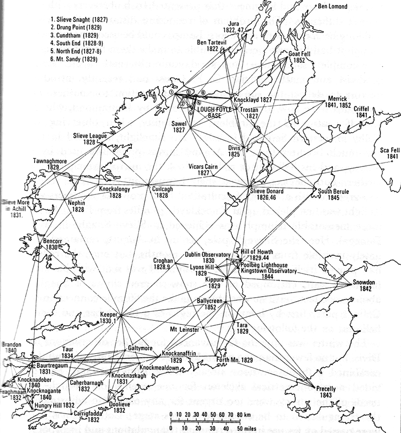
With some of the sightings over 150kms, Colby needed more powerful light than that provided by the Argand Lamps he was using. Colby’s assistant, Thomas Drummond, who displayed unique talents as an inventor and mathematician, invented the Limelight. Drummond was also instrumental in improving the heliostat reflector which was used for daylight observations. Both devices received their baptism in 1825. J. H. Andrews in 'A Paper Landscape' describes the event.
"The reflector was greeted with a 'shout of exhuktation' by a crowd of sightseers when its light was first picked up at Knocklaid, 40 miles from Divis. An even more memorable triumph was achieved at Slieve Snaght in County Donegall. Here the Survey's pole, set up in Auguat, remained obstinately invisible from Divis for several months, but once the reflector had proved itself at Knocklaid, Drummond was sent with his instruments to wait, encvamped on the snow-covered slopes of Snaught at about 2,000 feet, until he was able to make the 66 mile connection with Colby's party first by lamp on the night of 9 November and then by heliostat on the following day."
In order to complete the network of triangles, the length of one leg of one triangle had to be measured. The leg chosen was along the shores of Lough Foyle and this measured distance is known as the Baseline. The accuracy of the measurement of the Baseline was paramount as it set the scale for the whole survey. Colby, not satisfied with previous methods of measuring baselines, asked Drummond to develop a method based on the compensation principle, using parallel bars of two different metals (iron and brass). Drummond’s design allowed the bars to be connected in the middle with steel tongues fixed across the ends, leaving them free to shift according to the expansion or contraction of each bar and allow the coefficient of expansion of metal to be used in the calculation of distance.
Measurement of the baseline began in 1827 and was carried out under tenting to avoid fluctuations in temperature. The bars were mounted on tripods and the total distance of 7.89 miles, which included crossing the River Roe, was completed in November 1828 after 60 days of measurement by 70 men. The accuracy achieved is still marvelled at today.
Based on an item at http://www.osni.gov.uk/index/aboutus/history.htm
with additional information from various sources.
Ordnance Survey
in Ireland
| 1824 | Ordnance Survey Ireland (OSi) established.
Major survey by Thomas F. Colby begun.
The History of Ordnance Survey |
| 1827 to 1828 |
The Lough Foyle Base Line |
| 1839 to 1843 | The first levelling of Ireland.
Poolbeg Datum |
| 1846 | Colby's survey was completed. |
| 1867 | A more comprehensive survey was completed. |
| 1921 | Ordnance Survey N.I. set up |
| 1952 | Northern Ireland Retriangulation |
| 1957 | A new vertical datum for NI.
Belfast Datum A combined datum for OSi and OSNI was also established at Malin Head. |
| 1959 | Republic of Ireland Retriangulation |
| 1970 | The work of adjusting the observations from the
Republic of Ireland and from Northern Ireland to form one entire network related to MSL Mailn was completed.
Malin Head Datum |