The Retriangulation of Ireland.
|
|
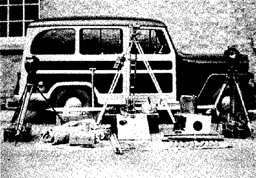
Some equipment of the period. One of the problems was transporting this heavy equipment up to some of the highest mountain tops in Ireland. Donkey power was often used for the job. |
 |
Login |
| Grid Ref. Search Detail Map About ... Home | |
| User Area Register Links Gallery |
|
|
|
Some equipment of the period. One of the problems was transporting this heavy equipment up to some of the highest mountain tops in Ireland. Donkey power was often used for the job. |
| 1824 | Ordnance Survey Ireland (OSi) established.
Major survey by Thomas F. Colby begun.
The History of Ordnance Survey |
| 1827 to 1828 |
The Lough Foyle Base Line |
| 1839 to 1843 | The first levelling of Ireland.
Poolbeg Datum |
| 1846 | Colby's survey was completed. |
| 1867 | A more comprehensive survey was completed. |
| 1921 | Ordnance Survey N.I. set up |
| 1952 | Northern Ireland Retriangulation |
| 1957 | A new vertical datum for NI.
Belfast Datum A combined datum for OSi and OSNI was also established at Malin Head. |
| 1959 | Republic of Ireland Retriangulation |
| 1970 | The work of adjusting the observations from the
Republic of Ireland and from Northern Ireland to form one entire network related to MSL Mailn was completed.
Malin Head Datum |
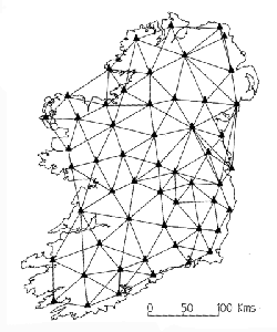 Ordnance Survey of Ireland began their retriangulation in 1959. Many of the points observed in the principal triangulation
of the nineteenth century were incorporated in the new scheme. Triangulation stations, in the form of the familiar concrete
pillars seen on many hill tops, were erected.The Irish Grid co-ordinated values of triangulation points are available to the
public and are used in many engineering and other special surveys.
Ordnance Survey of Ireland began their retriangulation in 1959. Many of the points observed in the principal triangulation
of the nineteenth century were incorporated in the new scheme. Triangulation stations, in the form of the familiar concrete
pillars seen on many hill tops, were erected.The Irish Grid co-ordinated values of triangulation points are available to the
public and are used in many engineering and other special surveys.