
Trostan
Original Data: D 17956 23593 Height: 332.9
| 2015-07-25 Biffin reported: D 17956 23593 | Elev:0
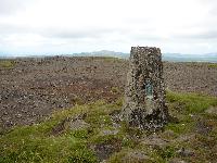
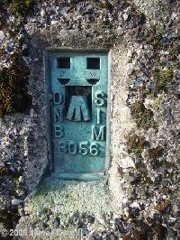
| FB:3056 | Pillar:Good | View:Excellent
Great views across to Scotland and south to the IOM and the Mournes. With Joel. |
| 2007-07-18 Bridgeman reported: D 179 236 | Elev:550
| FB:OSNI3056 | Pillar:Good | View:Good
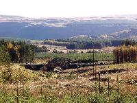
Started out from Essathohan Bridge but as there was early morning mist made a detour via Parkmore Forest and Agan Bridge. I followed the waymarkers on the moyle Way up onto the moor on the southwest side of Trostan but even on the latest OS 1;50,000 map the maymarkers re-route you further south on a forest path. The route through the forest is extremelt wet and spongy underfoot with peaty drainage channels to cross. Once on the open moor, it is easier but still wet. If you continue to 50 metres short of the highest waymarker of the Moyle Way there is a faint path on the right which can be followed right to the summit although it is easy to lose. On the summit area the vegetation gives way to quite a stony area to give some easy walking. |
| 2006-11-03 JC reported: D 17961 23597 | Elev:561
| FB:OSNI 3056 | Pillar:Good | View:Excellent
Parked the car in a wide gateway at the foot of the mountain. The plan was to follow the Ulster Way as far as its' closest point to the TP then cut cross country to our goal. The trail follows a river for almost the first kilometer. Where the track up the side of the trees meets a forest road at the top of the hill. We Followed the river through the forest then turned right through a ride. It proved to be very rough and boggy. We crossed a style out of the forest and followed the fence up the mountain then cut cross country towards the TP. We eventually spotting the TP. When we arrived we took the usual pictures, GPS waymark and sat down for a well earned rest and lunchbreak. The views were magnificant! |
| 2005-05-07 Saginanivalis reported: D 179 236 | Elev:0
| FB:NI3056 | Pillar:Good | View:Not Applicable
OSNIBM 3056, vgc, spider, metal cap unlettered apart from small IPEC trademark. Primary trig. Stony peaty summit, unexciting view. via Moyle Way from SE, boggy thru forest. |