

Muckish
Original Data: C 004 287 Height: *
| 2008-09-20 dino reported: C 00449 28720 | Elev:683
| FB:J2(?)794 | Pillar:Slightly Damaged | View:Excellent
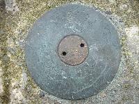
Despite the last log I managed to get my car to the little car park at the bottom of the Miner's Track with no problems. Another car and a van made it up too but that was about it for parking. Had a great climb up to the top which took me about 1 hour (45mins for return trip). The views from the top were fantastic with a clear sunny day and panoramic 360 views. Wonderful place today and a much more interesting mountain than I expected! The trig is in good condition except for a bit of inevitable weathering in such an exposed location. The top-plate seems to be inscribed with a number and a stylised Celtic design which appears to me to be a dog. The number is either J20794, J29794 or J2794 but as there has been an attempt to deface the surface it's difficult to be sure. I've attached a picture anyway. According to my GPS the height read 683m and was a distance away from the marked spot height when I plotted it on an electronic map but I'm not sure how accurate that may be. |
| 2008-07-11 Bridgeman reported: C 004 287 | Elev:666
| FB:NA | Pillar:Slightly Damaged | View:Good
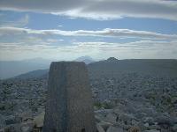
Walked from grid ref C009309 to make walk into a circular. The road now continues to B999293 (not shown on older maps) and the last 200 metres to the old quarry buildings is a rough track and not recommended for cars. Ascended via the interesting Miner's Path then crossed summit plateau to trig point. The trig point is not shown on the Ordnance Survey Map but is at spot height 666 metres. Large iron cross 150 metres to NNE and large cairn to WSW. Summit plateau is strewn with rocks. |
| 2005-05-06 Saginanivalis reported: C 4 287 | Elev:666
| FB:N/L | Pillar:Slightly Damaged | View:Good
OSI trig, top slightly damaged, unmapped on 50k, on massive ancient cairn, metal cap. fine quartz-strewn summit, fine views, fine coum to N. Large cross - to counteract the 666m summit height?! |