
Errigal (Mountain)
Original Data: B 92821 20770 Height: 750.7
| 2018-06-03 Biffin reported: B 92821 20770 | Elev:0
| FB: | Pillar:Definitely Missing | View:Completely Obscured
No sign of a pillar. Cloud-covered summit. With Matt & Joel. |
| 2008-07-13 Bridgeman reported: B 92821 20770 | Elev:751
| FB:NA | Pillar:Definitely Missing | View:Partly Obscured
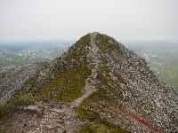
Started out from grid ref B936255 by Prockis Lough and headed up Errigal from the north initially along bog track then over rough moorland before tackling a steep unstable scree slope and then a bit of scrambling to reach the summit. There is a sketchy path on much of this steep ascent. Errigal has twin summits the southern slightly the higher of the two. No trace of trig point. Descended via tourist path before walking over Maclaght and Aghla More and crossing the Tullaghobegy River at the northern end of Altan Lough (fairly striaghtforward if river not high). You can pick up a track on far side. |
| 2005-05-05 Saginanivalis reported: B 928 207 | Elev:0
| FB:NA | Pillar:Definitely Missing | View:Unknown
no trace of trig: some concrete in cairn some way to E of summit i.e. wrong loc. Primary trig. In cloud. |